

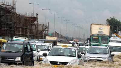
Delhi, the city that was just bracing for summer heat, has suddenly pulled out its woollens again. Just when residents were expecting temperatures to soar past 35°C, the weather took a dramatic, almost bewildering turn. Rain lashed the capital and its surrounding NCR areas—Ghaziabad, Noida, Faridabad, and Gurugram—bringing a sharp, unseasonal chill. This wasn’t just a typical spring shower; experts are calling the system behind it a “rare” and “insane cover”—a massive 1,000-kilometre rain band Delhi’s Cold Snap powered by an active Western Disturbance. [1][2]
For the public, this sudden weather shift is a major news point, causing disruption but also offering a much-needed respite from the scorching heat Delhi had been experiencing just days before, with temperatures nearing 37°C. [2][3] But what exactly is this phenomenon, and why is it so unusual?
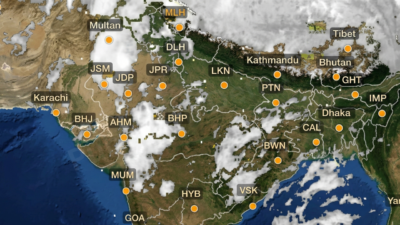
The Anatomy of an ‘Insane Cover’: The 1,000-km Rain Band Delhi’s Cold Snap

The core reason for Delhi’s sudden cold snap is an active Western Disturbance (WD) that has taken on a highly unusual structure. [1][4] Western Disturbances are typically extratropical storms that originate over the Mediterranean Sea and bring winter snowfall and cold waves to North India. [4][5] However, this system is different in two critical ways: its timing and its shape.
1. The Rare, Straight Trough
Normally, Western Disturbances travel in a curved pattern. [6] This time, however, the system has formed a strikingly linear low-pressure trough—a straight line spanning thousands of kilometres—stretching from Afghanistan, through Pakistan, and deep into India. [1][4]
Weather experts have noted this straight-line formation is “generally very rare.” [1] This linear structure acts like a massive, concentrated corridor of low atmospheric pressure. [5] When the trough is this straight and long, it significantly amplifies the system’s strength, giving it the capacity to create very strong thunderstorms, thunderclouds, and intense downpours. [1][2]
2. The Unseasonal Timing
The second unusual aspect is the timing. This phenomenon is peaking in mid-to-late March, right when the region should be transitioning into summer. [4][5] By late March, this kind of intense WD activity typically tapers off as the jet stream weakens and shifts north. [5] The fact that such a powerful system is active now, bringing winter-like conditions, underscores a growing trend of increasingly erratic and volatile weather patterns across South Asia. [5]
The Impact on Delhi-NCR Delhi’s Cold Snap
The direct consequence of this moisture-laden system has been a dramatic drop in temperatures across North India. [4]
- Minimum Temperatures Plummet: Delhi-NCR woke up to rainfall and a yellow-coloured warning on Friday, with the minimum temperature settling at 16 degrees Celsius, which is 4.5 degrees below normal according to IMD readings from the Safdarjung weather station. [1]
- Maximum Temperatures Dip: On Thursday, scattered showers and strong winds kept the maximum temperature below 30°C for the first time in nearly a month, settling at 26.8 degrees Celsius—4.7 degrees below normal. [1] This was the lowest maximum temperature recorded in Delhi since February 24. [1]
- Wider Region Affected: The rain band is not confined to Delhi; it is lashing adjoining areas like Ghaziabad, Noida, Faridabad, and Gurugram, while similar weather is being reported in parts of Pakistan and Afghanistan. [1][4]
The system has brought intense rainfall, thunderstorms, lightning strikes, and powerful gusts, offering a stark contrast to the unseasonal heatwave Delhi experienced just days prior. [2][3]
Expert Caution and Official Advisories
Meteorological experts have urged the public to remain cautious and follow advisories from the India Meteorological Department (IMD). [1] The IMD has been actively issuing warnings, including a yellow alert for Delhi-NCR, forecasting moderate to heavy rainfall, thunderstorms, gusty winds, and even hailstorms across northwest India. [1][2]
Climate scientists have pointed out that the structure of this trough is what gives it its intensity, capable of generating severe weather events. [1] While the rain brings relief from the heat, the associated strong winds and potential for intense storms necessitate vigilance from residents.
Looking Ahead: Erratic Weather to Persist
Delhi’s Cold Snap While the skies over Delhi might clear temporarily, weather experts warn that instability is far from over. [2] Such strong, moisture-laden systems signal evolving weather patterns. For the public, the main takeaway is that the weather in North India is becoming increasingly unpredictable, with the potential for sudden, intense events outside the usual seasonal norms. The “1,000-km rain band” serves as a stark, tangible example of this meteorological shift, wrapping Delhi in an “insane cover” of cold and rain when it should be preparing for summer.